|
|
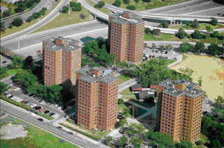
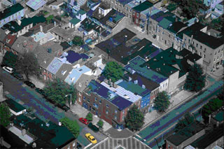
Planning For DensityWhat comes to mind when you hear the term density? Buildings stacked upon each other? Structures that stretch into the sky? Congested streets? What does density look like? How does a neighborhood with ten units per acre compare to a neighborhood with fifty units per acre? Density ratios alone rarely reveal the physical character of a neighborhood. Two neighborhoods with identical densities can look very different. For example, 4 housing units per acre can be 4 single family detached houses evenly spaced over 1 acre or can be a cluster of four multifamily units concentrated in the center of a lot. In the latter case, more open space around the periphery of the multifamily units could give the impression that the neighborhood is less dense.  The two pictures below illustrate the same density – 33 units per acre – but a significant difference in the development pattern. The pattern of development affects how density appears in the environment. Neighborhood development patterns typically determine whether areas seem comfortably or uncomfortably dense. The street network, orientation of buildings, distance the buildings are set back from the street, landscaping, and sidewalks can be used to adjust our perception of an area's density. Low density single-family neighborhoods have the space to provide garages, parking, and landscaping on individual housing lots. As density levels increase, space between housing units is reduced, also reducing yards and parking spaces. Urban design becomes more important in higher density development. Well-designed, high-density urban neighborhoods can offer a concentration of jobs, retail and dining establishments, and other benefits. With the appropriate design tools, Orange County can offer a full range of housing choices and living environments to meet the needs of its residents. The Density Catalog provides examples of different development patterns at the same density level. Providing Amenities in High Density Neighborhoods The Lincoln Institute of Land Policy's Visualizing Density website notes that green infrastructure, public and private space, variety, great locations, and other amenities are factors that lead residents to choose high-density neighborhoods. Connection, especially pedestrian connection, is a significant amenity. Street networks that provide direct connections between blocks and open spaces are important factors. An interwoven green infrastructure of street trees, landscaped streets, wetlands and wooded areas, in a neighborhood provides amenities in high density environments. Public spaces in strategic locations can compensate for the lack of yards in high-density environments. Well-designed public plazas or parks can provide a place for socializing and can establish community identity. Private space, with careful planning, can be included within even the most dense neighborhoods, depending on the placement of buildings, structures, roofs, landscaping, and other design features. Variety is a significant amenity in higher density areas. Contrasting architecture and building types, open spaces, and streetscapes provide aesthetic interest in neighborhoods. Variation in building styles, details and colors provides visual stimulation and neighborhood vitality. Location is the quintessential amenity. A location along water, valleys, parks or other natural beauty often provides attractive views. By concentrating housing units vertically on one parcel or innovatively through architectural design, more housing units can access the view. Access to downtown, centers of employment, various institutions, public transportation or other also add to the desirability of living in high-density areas. |
|